ˇ@
|
ˇ@ |
ˇ@ | Home |
| ˇ@ | ||
|
|
|
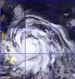
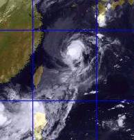
Typhoons are low pressure systems, with their pressure gradient gradually increases towards centre. Usually, the circulations have diameters of several hundred to a thousand kilometres. However, there are exceptions. Below are the satellite images of Typhoon Utor in the year 2001. While Utor was approaching Luzon of the Philippines, it developed both in size and strength. In its mature stage, the circulation extended almost 2000 km. Later, it affected the Philippines and Taiwan simultaneously, before it targeted at Hong Kong. For details of Utor, please see 'My Memories'. |
  |
|
Fig. - The five satellite images, from left to right in chronological order, showed Utor developing over the Philippines Sea. Notice in the third image, Utor attended its largest size, with diameter approximately 2400 km! How long is 2400 km? It is about three times the distance between Hong Kong and Taipei, or you can drive through the storm in 30 hours if you keep your speed at 80 km/h! |
| ˇ@ |
|
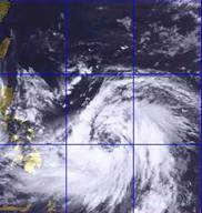
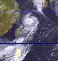
Another extreme storm again occurred in 2001. Typhoon Nari developed east of Taiwan, lived a long long time despite its tiny size. It was only a 200 km-system when it struggled around the midway between Taiwan and Japan. After circling over the sea for a few days, Nari headed towards the northeastern tip of Taiwan, where serious damage was found. Surprisingly, Nari then came close to Hong Kong afterwards, which was a rare track over the years. |
 |
 |
 |
 |
ˇ@ |
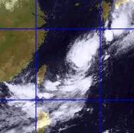
| Fig. - This time let's see the satellite images for Nari. Nari maintained as a small system throughout its life, though it had similar strength as Big Utor. In the fourth image, eye of Nari can be easily identified, but diameter measured was no more than 400 km. Notice that these images were taken over a period of about ten days - Nari was almost stationary for days and nights! |
ˇ@
|
|
Fig. - Here I combine the images of Nari and his big brother Utor. Since the ratio of their diameter was about 400:2400 = 1:6, their coverage ratio would be 1:36! |