ˇ@
![]()
|
ˇ@ |
ˇ@ | Home |
| ˇ@ | ||
|
|
||
|
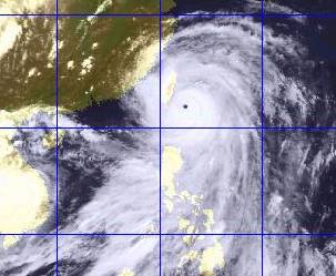
The Joint Typhoon Warning Center (JTWC) of the US classifies storms with sustained maximum winds near centre of over 125 knots (about 231.5 km/h) as 'Super Typhoon'. Normally, several storms are able to develop as 'super'. Typhoon Bilis in 2000 was a typical case. Developed around Yap, it moved NWward towards Taiwan and, winds of 220 km/h were recorded before landing. Hong Kong was affected by the rainbands of Bilis, though the territory kept distance from the perfect storm. |
 Fig. - Bilis brought thunderstorm to Hong Kong. The Observatory issued Black Rainstorm Warning in that evening. |
ˇ@
Fig. - Typhoon Bilis with its intense wind and clear eye. ˇ@ |
|
|
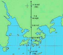
Tropical Depression on 19th June, 2000 successfully brought a 4-hour sensation of storm to people in Hong Kong. It was born just south of Lantau Island, moving northward rapidly. Finally, it landed over Tsuen Wan of Kowloon, bringing a short and weak stormy feeling to our normal life. |
|
Fig. - Track of Tropical Depression over Hong Kong. The tropical cyclone warning signal was hoisted for only 4.5 hours - a recorded low so far. |
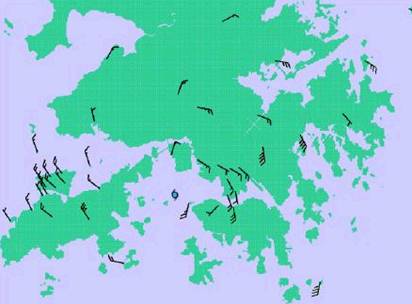 |
Fig. - The wind speed and direction in various places of Hong Kong at 10 pm. Notice the wind blew anticlockwise around the eye of Tropical Depression. |
ˇ@